

FROM WHICH SUBURB CAN YOU GET TO COLOMBO THE FASTEST?
With property prices sky-rocketing in the city centre of Colombo, many property-hunters look to the suburbs for their next purchase.
However, if you’re like many of them, you probably still have a job in the heart of the city. This, as a result, probably means that travel time to the city is a primary concern for you.
Let’s then explore, which popular suburban areas have the fastest routes to the city centre.
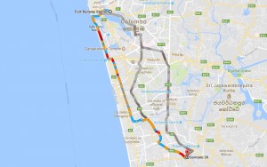
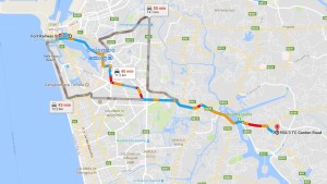
To do this, we’ll take a landmark in the centre of the city. In this case, we can take the Colombo Fort Rai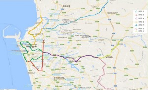 lway Station. Then we’ll take a landmark in each suburb and compare the travel time using Google Maps.
One major development that would affect these suburbs would be the RTS service. This proposed RTS – Rapid Transit System (shown in image 1 below), is expected to mainly consist of a Light Rail Transit (LRT) system. It will be combined with an electrified conventional railway system, a reorganised bus service, an inland water transport system that will use Colombo’s historic canal network as well as a new metropolitan expressway system, to move commuters quickly and efficiently in and out of Colombo.
From Dehiwala–Mount Lavinia
 Time taken to reach Colombo by car – 44 minutes
To understand the time it’ll take you to reach Colombo Fort Railway Station from Dehiwala-Mount Lavinia, we took the Opal Residencies in Mount Lavinia as our landmark starting point. According to the Google Maps distance calculator, it could take you roughly 44 minutes to travel this 14.3 km distance. As proposed by the Western Region Megapolis Planning Project (WRMPP), the Elevated Rapid Transit System (RTS) – Line 1 (shown in dark green in image 1) is expected to pass through this route, allowing commuters to significantly reduce their travel time. If you’re travelling from Mount Lavinia, you can enter the RTS – Line 1 from Bambalapitiya, which should take you to the Fort Railway Station. You can also take the existing railway line from Mount Lavinia to reach your destination.
From Nugegoda
 Time taken to reach Colombo by car – 53 minutes
We took the Blue Mountain Nugegoda building as our landmark starting point. According to Google Maps, it’ll take you roughly 53 minutes to travel the 11.1 km distance between the and the Colombo Fort Railway Station. Fortunately, the WRMPP’s proposed Elevated Rapid Transit System (RTS) – Line 3 and Line 1 (shown in dark red and green in image 1) will cross halfway along this route, helping to reduce your travel time. If you’re travelling from Nugegoda, you can take the RTS – Line 3 from Kirulapana, which should take you to Borella. From there, you can take the RTS – Line 1 to reach the Fort Railway Station in Colombo.
From Kohuwala
 Time taken to reach Colombo by car – 40 minutes
Our landmark starting point in Kohuwala was the elegantly built Sovrano 39 apartment complex. Google Maps will show you that it’ll take 40 minutes to travel the 11.1 km distance to the Fort Railway Station from Sovrano 39. Fortunately, for you, both the proposed Elevated (RTS) – Line 1 and the Elevated (RTS) – Line 3 (shown in dark green and dark red in image 1) will crisscross this route. Therefore, if you’re starting your journey from this apartment complex in Kohuwala, it is possible for you to take the existing railway line from Nugegoda, located less than a kilometre away, in order to reach the main railway station at Fort. The proposed modernized bus service should also assist you to travel across Colombo, which should save you both time and money compared to taking a car to your destination.
From Battaramulla
 Time taken to reach Colombo by car – 40 minutes
Our landmark starting point in Battaramulla is none other than the Prime Residencies apartment complex located in the Battaramulla city. According to Google Maps, it could take you roughly 40 minutes to travel the 11.2 km distance to the Fort Railway Station. Nevertheless, thanks to the WRMPP, you’ll be able to take the proposed Elevated or at grade (RTS) – Line 4 and the Elevated (RTS) – Line 1 (shown in dark purple and dark green in image 1) to quickly reach your destination. Nevertheless, in order to reach the main railway station at Fort, you should take the RTS – Line 4 from Battaramulla, which should take you to the Borella junction. From there, you would be able to take the RTS – Line 1 that’ll take you to your destination. Conversely, you should also be able to take the IW1 inland water transport system that starts from Battaramulla. However, this waterway would only take you to Wellawatta, where you would have to take a train to reach the Colombo Fort Railway Station. Such systems would cost you far less than if you took a car to your destination.
From Rajagiriya
 Time taken to reach Colombo by car – 51 minutes
We chose the eye-catching Sky Gardens apartment complex as our landmark starting point in Rajagiriya. Google Maps shows that it could take 51 minutes to reach the 9.4 km distance, to the Fort Railway Station from here. However, the proposed Elevated or at grade (RTS) – Line 4 and the Elevated (RTS) – Line 1 (shown in dark purple and dark green in image 1), of the Western Region Megapolis Planning Project may ensure that your travel time could be even shorter in the near future. Therefore, if you wish to reach the Fort Railway Station from here, you should take the RTS – Line 4 from Battaramulla that would take you to the Borella city. From there, take the RTS – Line 1 to reach your destination. You may also be able to take the advantage of the modernised bus service or the inland water transport system to move in and out of Colombo.
It is quite evident that reaching Colombo through main roads have turned out to be a never ending hassle mainly due to major traffic conditions. With many vehicles coming into the road, getting to your desired destination on time is close to impossible. However, while there is nothing much we can do about it at this moment, we believe that these easy routes mentioned above will be useful to you to figure out the shortest way that you can reach your destination without having to face any inconvenience.